Showing posts with label Fatass. Show all posts

Thursday, July 3, 2014

CATass 50k

While many of our friends will be running the VT100 on July 19, those of us left behind can have our own fun at the CATAss 50k. Created as a training run for Western States by our friend Andy Jones-Wilkins, the CATAss is a true Fat Ass in that there is no fee, no T shirts, no wimps and no whining. There will be water and heckling at miles 5, 12 ( a spring), 19, and 25, and the requisite post-run story telling, eating, and drinking.

The course combines the New Year Day Rendevous Run with the Harry Landers Special. First, runners will run to Blackrock from Sugar Hollow:

http://www.vhtrc.org/trails/sugar-hollow/sugar-hollow-blackrock

Then they will head north from Blackrock on the AT and run the Doyle's River and Jones Falls Loop CCW:

http://www.shenandoahviews.com/Waterfalls/DoylesRiverFalls/loft_mountain_jones-doyles.pdf

They will return to Blackrock on the AT and continue south to Turk Branch Trail and the finish at Sugar Hollow:

http://www.vhtrc.org/trails/sugar-hollow/harry-landers-special

More details will be forthcoming. If you are looking for a solid, hot, hilly, beautiful training run for your fall ultras, come join us at the CATAss 50k.

Wednesday, July 4, 2012

Sophie's Death March

This past Saturday, after the Derecho rolled through, runner friends of Sophie Speidel gathered from far and wide to run "Sophie's Death March." Runners from (at least) Harrisonburg, Richmond, the D.C. area, and a few CAT Runners joined in the fun. Look at that group!

Water bottles in the front indicate camera-woman Sophie
Marc Griffin, who ran the Eastern Divide 50k the week before, drove to Cville in the wee hours of the morning, and the two of us then met up with Stuart Brown by the airport up 29, before making our way over to the Whiteoak Canyon area in the Shenandoah National Park.

The loop begins with a 5 mile climb with ~3000 feet of gain from the parking area up to Hawksbill, the highest point in the SNP. Sort of a rough start, but the trails are great, and Marc and I settled into a nice relaxed pace behind the really speedy group. Mostly our goal was just staying on trail, as I've only done this loop once (and with folks who knew where they were going), and Marc missed a turn last year and ended up a few miles south of where we were supposed to be. So we took our time, stopped at intersections to check our maps, and managed to make it to the top without issue. Climbs might hurt a bit, but the views are almost always worth it:

Looking West(ish) from Hawksbill
Looking East(ish) from Hawksbill
We couldn't quite see it, but apparently if you knew what you were looking for up there, you'd have been able to see the smoke from a wildfire in the SNP, another 20+ miles North.

Anyway, shortly after we started down from the summit, we ran into Regan, Jack, and Marlin, and decided to run with them. So we spent a few more minutes hanging out on Hawksbill, and then made the descent down to the Appalachian Trail. It was somewhere around here I started thinking I could probably be happy ducking out from the full loop (~24 miles), and just doing 17ish. Sophie's loop had us taking the AT up to Skyland, where there's a lodge and we were able to refuel (despite the power being out). As we gathered back up, Regan convinced us that the long loop really wasn't that much longer, and was totally worth it, so off we went. North on the AT, we skipped the little out and back for Stony Man, and just kept on chugging along to the turn for Corbin Cabin. With most of the climbing out of the way, I was feeling pretty decent on this section, and as a group we were able to keep up a pretty solid pace. I was walking hills I didn't need to be, but as this was going to be my longest run since January, with only an 18 miler a few weeks earlier, I was guessing things were going to fall apart for me.

Though temperatures were forecast to be up near 100, we had a nice early start, and the storms the night before seemed to have helped keep things a little cooler than expected. Getting up a couple thousand feet also helped the temperature, and there were some lovely breezes at Hawksbill and along the AT. I don't remember what time it was we would have been starting back down off the mountain, down the Nicholson Hollow Trail, but it was definitely starting to heat up. Fortunately, this section of trail has lots of stream crossings, which we were happy to stop and cool off in. The water was delightfully chilly, and helped keep us moving. In one of the last crossing before hitting the Weakley Hollow fire road, we actually saw a water snake, which was pretty exciting, if not too worrying.

The fire road was the section I was least looking forward to, and part of the reason I wanted to cut my run short. It's a 5ish mile section of dirt road (which was sort of a relief, as I thought it was more like 8 miles), but the first half is all uphill, with the final nearly 1000 feet of climbing for the day. Last year I was in much better shape and managed to push through this section pretty well, but this year was much happier to walk more than I "ran". At the top, the road hits the Old Rag fire road, where the shortcut would have dropped in. Despite my fears, and general apathy about running the hill, nothing really fell apart for me, which I was very glad for. The final two mile descent was pretty sweet, and Marc and I ran into Stuart who had opted for the 17 mile loop, on account of his "fascist" foot, which worked out pretty well for getting back into the car at the finish.

One of the nice parts about the finish, for this run, is the little creek right at the parking lot. On the way in, I thought it looked pretty barren, but apparently it was enough to keep hot and tired runners happy:

The other good part about the finish was that this was very similar to other VHTRC outings I've been to, with a great tailgate at the end. The park rangers were reasonably impressed.
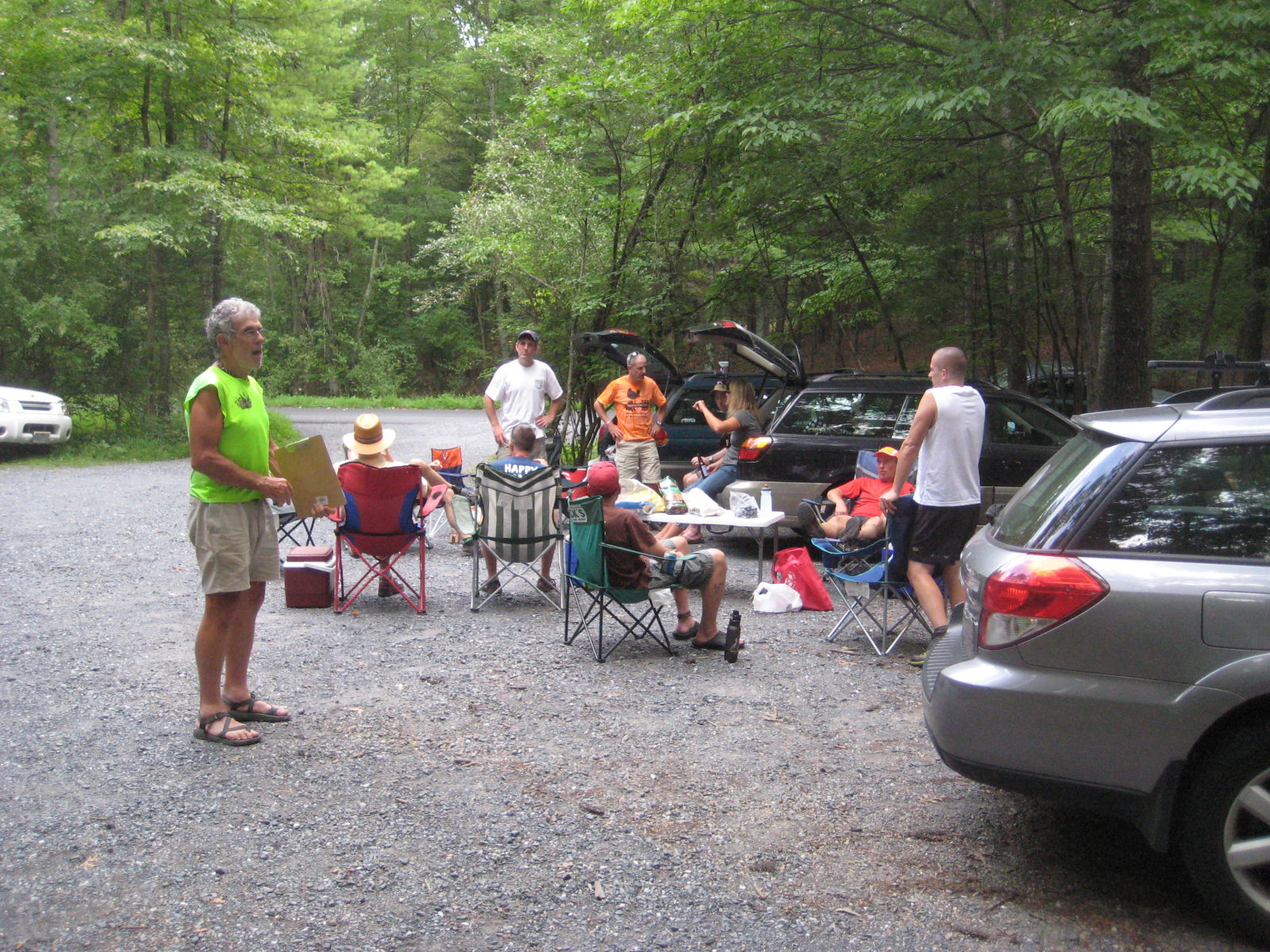
Typical VHTRC post-run
After a relaxed hour or three of great food, camaraderie, story telling, and watching Gary Knipling bounce around and keep everybody smiling, we three CAT Runners headed home, eager to return again next year.

Gary, still a bundle of energy after several hours on the trail

Thursday, October 20, 2011

Recap of Beautiful Training Weekend: SMUT and 3 Ridges/Priest

Fall mountain splendor. Courtesy Jenny Nichols
Last weekend saw several great training opportunities and for many of us it was the last long-run weekend before the upcoming Mountain Masochist 50 miler.  It was also a spectacularly beautiful fall weekend to be in the mountains.

Below, Christian provides a quick summary and some nice pictures from Saturday's SMUT (Southern Massunutten Ultra Trail) 50K, put on by Keith Knipling, and David does the same for Sunday's CAT training run at 3 Ridges and the Priest.

Christian's report from SMUT

The SMUT (Southern Massanutten Ultra Trail Run) is another low-key fat ass event that Keith Knipling from the VHTRC has put on every year for five years now.  Keith offers a 50k and a 100k option (both fall a little short of distance though). We CAT's (Joey and me) opted for the 50k option and had a blast. As an "entry fee" everybody got assigned aid to bring to stock up the aid stations. Needless to say, there was a wide variety of aid and plenty for everybody.

Since there are no course markers we hung with Gary Knipling and Marlin Yoder (both team VHTRC)  almost the whole way to not get lost. We dropped Gary when he realized we were "just" in for the 50k. In addition we were provided turn sheets and Joey even brought a PATC map. It was just over 50F at 6:30am in the morning as we started up a gravel road for about 1.5 miles, and entered the singletrack trail by sunrise. Fall foliage and the sun coming up behind the mountain range offered gorgeous views as we ran on the first ridge. With 6000ft of elevation gain over 28.8 miles it was a good workout and I cursed the Massanutten rocks a couple of times. The course offered lots of rocks, some jeep roads,  single track, beautiful views and great company. The run was very nice and Joey and I finished in 6hrs 30mins.

A really nice low-key, no-pressure fat ass event with lots of VHTRC love, I would definitely recommend it! Here some impressions from the beautiful fall day.


David's report from 3 Ridges/Priest

Fall colors on AT.  Courtesy Jenny Nichols.
We had a great and fun group turnout for Sunday's run, with folks from all over Virginia.  When Nick Hamblet and I pulled into the Rte. 56 parking lot around 7:15 am, we met up with CAT-regular Bob Clouston, Matt Bugin and two other friends from Richmond, IMTRers Jenny Nichols and Guy from Southwest Virginia, and VHTRCer Quatro Hubbard from Richmond.  And then, CAT-regular Neal Church showed up from Richmond to round things out.

It was a picture perfect day with temps in the 50s as we got started.  Guy and Skinny B Nick started out with Matt Bugin and friends in a fast group, followed by Bob, Jenny, and Neal.  Quatro and I decided to "sweep" in the last grouping.  We first headed up the AT towards The 3 Ridges.  The colors were great; we started down in green leafy late summer, ascended through oranges and reds, and came up to yellow-colored trees and paths of fallen leaves on the top of the ridges.  The views were outstanding, as Bob's and Jenny's pictures, included here, can attest to. The Mau-Har trail was great -- much nicer in autumn than in the humidity of the summer IMO-- and Campbell's Creek flowed strong and clear from recent rains.
Jenny and Neal on the Third Ridge. Courtesy Bob Clouston.

Quatro on Third Ridge with Priest in background.
Nick, Bob, and Neal on Priest outcropping.  Courtesy Jenny Nichols
Quatro and I finished the first leg in just over four hours and found Jenny, Bob, and Neal still hanging out in the parking lot. So we grabbed some quick food and drink and headed up the Priest trail all together.  We were met by another beautiful climb and great scenery at outcroppings as we ascended higher.  It was at the first outcropping about 2/3 of the way up that Bob, Jenny, and Neal met the fast group on their way down.  I caught up as they all snapped off more pictures (Q returned to the parking lot about a mile up the trail as the 24 miles he ran with Sophie Speidel plus several hours of UVA tailgating on Saturday began to catch up with him).   On top of the Priest, we visited the other outcropping with its incredible vistas, before turning for our descent.  As this was my first time up the Priest, I was sort of dreading the descent, figuring my quads were shot.
Tailgate!  From L:  Guy, Jenny, Quatro, and Bob.

 But we got down in what seemed like no time at all with my quads still intact. The big surprise upon our return was the spread that Q had set up at his car.  It was the UVA tailgate all over again, complete with fried chicken, lots of chips, a variety of beers, and bourbon and cokes.  Jenny added some 5-hour energy shots and Lusty Monk mustard and we were in business!

Overall, the day included 22 miles of distance and 7350 feet of climbing.

Monday, August 15, 2011

Martha Moats Baker Memorial 50k


This past Saturday some CATs (Bob, Drew, Sophie and me) ran another free event put up by Dennis Herr from VHTRC. As always, VHTRC events are guaranteed fun and you can experience the dedication those folks put into their events.


Joe Schramka running through the clouds
Drew and I carpooled to "in-the-middle-of-nowhere"-Stokesville, VA (the Harrsionburg side of the Massanutten. The complete course is about 35 mi long and provides a decent elevation gain of 8400 ft. Thanks to the Waypoints Drew put in his GPS, we made it to the parking lot at 6.20am, and got one of the last empty spaces. After gearing up and packing map (and yes, Thanks Snipes for giving us an extra map) & turnsheet in the hydration pack we (25-30 runners) came together for a group picture. Many of them took the shorter, 26/28mi option of the course. In a short pre-race briefing, Dennis pointed out that we shouldn't cross the "flower" line, I thought this was a little odd, but given that we trail runners usually are nature conscious it made sense, kind of. (It took me about 20some miles to realize that a flower-line was a flour-line as in course marking. Go figure.). In perfect weather (in the 60/70s) we took off.


The plan was to run with Drew and go for the full distance. Coming back from a beach vacation (and 34ft elev gain runs) two days prior, I figured I need to get in some extra climb. We ran with Sophie, Bob and a few others for the first miles. Sophie gave us some tips along the course of easy to miss turns that served us well in the end (and yes, also arrows put down by David Snipes!). I separated from the group and ran in front with Joe Schramka, one of the WUS'ses (Woodley Ultra Society). I enjoyed getting to know him and talk about running. Drew caught up with us a few miles later and we refueled at the first aid station at Reddish Knob:
1st Aid Station at Reddish Knob (13mi)

We kept checking the turn sheet as we continued on the course as some turns were not obvious. The vegetation of parts of the course seemed like in California, pine trees and lots of grass - a nice change compared to the AT & Blue Ridge. Quite a few times we had to bushwhack as the bushes were covering the trail. We ran at a good pace and didn't think anybody would catch up soon, shortly after - out-of-nowhere, Eva Pastalkova, flew by with a quick "Hi, guys!". Even though she started 34mins late, she passed everybody! Crazy!

After the second aid station (21mi) we hit a short but nice cooling rain shower. Sweet! Some more uneventful ups and downs until we stopped at the last aid station, Grooms Ridge (27mi). 
If I had known that the final "brutal climb" meant brutal climb I might have not smiled here.
The final stretch (that many skipped for a reason) was about 4mi up and 4mi down. At this point my legs were quite tired from going out fast on the downhills earlier and I noticed that I didn't keep up with my nutrition too well - I felt a little empty. Also the weather turned to the sunny side and let the temps rise to 85-90F?! Yay! I think it took us about 2hrs for the 4mi up and 1 hour down. I let Drew take off and ran/walked the rest.
Rewarding views on the final miles..
The finish party was great (as VHTRC-usual), lots of food and drinks and good company. We were surprised to hear that Eva didn't make it to the finish yet... as it turned out she had run 10-bonus-miles. Drew (7:50hrs) and I (8:01hrs) made the first two places (out of 6 that did the whole course). Good times!

Party at the finish.
Thanks to Dennis Herr and all the wonderful volunteers who made this event possible. It was a great day, beautiful course, and a fantastic race.

Link to the event: http://www.vhtrc.org/events/mmb.htm
Photos by Christian:

Photos by Quattro:
http://www.flickr.com/photos/qhubbard/sets/72157627318827081/

Photos by Doug Sullivan:

Sunday, July 24, 2011

Catherine's Fat Ass 50K


Drew, Mike, Chris, Christian and Joey joined me up in the Massanuttens for the annual Catherine's Fat Ass 50K. Here is my blog post on our adventure!

Pictures by Christian

Made with Slideshow Embed Tool

Pictures by Brad Koening (VHTRC)

Wednesday, June 8, 2011

Flipped Truck Fat Ass 50k++

A few months ago I decided I wanted to do a long 30-40 mile run on June 5th. I would be going on vacation a few days after that date to an extremely secluded area where the surface area of water far exceeds that of land. Given the lack of continuous land mass, the possibility of running would be out of the picture during this vacation. Since I wouldn’t be running during the majority of this time, I figured I should probably get in a nice long run before my vacation started so I could utilize the downtime as true recovery time. I knew the North Face 50k/50 miler was going on in DC during this time, but that race didn’t appeal to me. I really wanted to get up into the mountains during my long run.

After looking over my options, I decided two loops in Sherando would be my best bet. The first loop would be around 16 miles and the second loop around 15 miles. I could start the first loop really early and hopefully begin the second loop around the same time as the usual CAT Sunday run. I thought by starting the second loop at the usual time I could get some folks to join me for the second loop and provide a bit of a mental boost. After putting out some feelers, however, it appeared there was no interest in joining up for the second loop, but there was quite a bit of interest from folks in joining me on the FIRST loop at 5:15 a.m.!

Come Sunday morning, I was on the road shortly after 4:00 a.m. Ground to lightening strikes were illuminating the sky north of Hwy 64, and I was questioning if the weather would permit running along the mountain ridges of Sherando. Shortly after 5 a.m. Bob, David, Christian, Joey and I were all standing in the dark parking lot off Coal Rd. contemplating which direction to run the first loop. The plan was to set out in the Mill Creek direction. However, I seemed to overlook the need for a headlamp at this early hour, and Bob had the good sense to recommend we start off running on Coal Rd. first where the running would be much smoother and safer without a light. The only concern we had with this option was that none of us had run the Mill Creek-Kennedy Ridge-Coal Rd. loop counterclockwise and there was some question to how easily we would pick up the Kennedy Ridge trail off Coal Rd.

We were correct to question our ability to locate the Kennedy Ridge trail from Coal Rd., as we ran ¾ mile past the trail before we decided to consult the map and better determine where the trail was. We eventually found the Kennedy Ridge Trail, but not before running an extra 1 ½ miles and losing a bit of time fumbling around. Unfortunately, David was in a bit of a time crunch and decided he wouldn’t be able to run the full loop with us, given the lost time trying to find the trail. While David got some extra miles in on Coal Rd., Bob, Joey, Christian and I started the climb up the Kennedy Ridge trail.

The Kennedy Ridge trail is both steep and quite technical in the miles closest to Coal Rd. When descending this trail, one is pushed into a feverish pace where you feel like you’re barely ‘holding on.’ Ascending the trail, however, offered the opportunity to take in what one hurriedly passes during these descents. With the mountain laurel still in full bloom and some exceedingly steep pitches, you’re literally forced to stop and smell the flowers now and again.

After regrouping at the top of the climb, we continued along the jeep road towards Bald Mountain. After rounding a corner a few miles into this section, Joey and I were stopped in our tracks. These trails are heavily populated with black bears, so being halted by a bear on the trail is not uncommon. However, instead of staring down a predatory mammal, Joey and I were staring, jaw-dropped, at a lifted Dodge pickup truck flipped on its side, consuming the entire trail. After getting over our initial shock, we had the good sense to run down and check to make sure the occupants of the truck were not in need of medical attention. Luckily, we found no people or signs of injury to the occupants (we did, however, find several empty beer cans that were shaken out in the tumble). We had some fun taking pictures and trying to piece together how the truck ended up where it was before continuing our run, a bit dismayed, at what we had just come across.

I think all of us were pondering all sorts of questions as to how that truck ended up where it was after we returned to running. About a half mile down the trail, some of these questions started to get answered. Joey and I were again forced to a halt as we saw two bodies lying motionless across the road. We gave pause and waited for ‘back-up’ from Bob and Christian before we approached any closer. As we stood waiting, the trail sleepers woke up, and they quickly identified themselves as the drivers of the truck. Aside from appearing a bit hung-over, they didn’t look any worse for wear (from the truck flipping, at least). Some terse conversation yielded a request for us to help them push their truck right-side up, which we declined, and we again continued towards Bald Mountain. Peeling off the trail to take the switchbacks down towards Mill Creek trail, we ran into a group of what appeared to be Boy Scouts. We informed the group of the two guys on the trailside and the overturned truck, and the adult leaders of the group put things into perspective further by recalling the caravan of pickup trucks, beds full of coolers and people boozing it up, that had been parading across the jeep road the previous night.

The rest of the run was much less eventful! We saw a bear, we finished the first loop. Restocked at the cars, and headed out for a second loop running from Coal Rd.-Mill Creek Connector-Torrey Ridge-Bald Mountain-Mill Creek back to the cars. Joey, Christian and I ended up running 35 miles. I’m still amazed that Christian (on his PT recovery path) busted out an impressive 35 miles. I was struggling during the second loop and here Christian is, still not 100%, running 35 mountain miles like it was nothing!

After finishing the second loop, we sat at the cars, ate some melted ice cream sandwiches, and relived the exciting moments of what came to be known as the Flipped Truck Fat Ass 50k++. Mark your calendars now for the first Sunday in June next year!
(Photo Credits to Bob C.)

Christian adds:
To be a-tune with my return-to-run program I was only planning on doing the first loop or at most 1,5 loops but couldn't say no to the opportunity and would have felt bad 'quitting' early. I suppose I ignored the 10-15%-weekly increase rule and replaced it by 10-15mi... I know it was probably not the smartest thing to do but what can I say, I am young and naive :) The run was great and I am glad I did it. I had to keep it slow and walk plenty of times but that was OK. woot woot mountains!